Saturday, December 31, 2011

Favorite Anchorages: Crease Island Cove

Recently on a late afternoon I was walking my dogs in the woods above my house, I heard a great horned owl hooting in the distance.  Immediately my mind flashed to a memory when I was anchored at Crease Island Cove up in BC's Queen Charlotte Strait area.  The owl's hoots made me shiver with the haunting memory of that night.

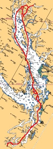
Quiet before the storm.  Looking SW.
We very much enjoy the Crease Island Cove anchorage.  It was late August and thunderstorms were predicted for the Queen Charlotte Strait area.  There was an eerie stillness in the air, and conditions were very warm and humid which is unusual.  The normal late afternoon winds were absent.  You could tell a thunderstorm was brewing as the weather radio had warned.  Gale to Storm force gusty winds were expected as well as lightning and heavy rain.  As a result the anchorage was unusually crowded with boats.  The depths of this anchorage are shallow, only about 15-20' over a mud and kelp bottom.  The anchorage will comfortably hold about 10 boats, but there were more than that this evening.  The thunderstorms were forecast to come from the west, and the cove provides good shelter from the southwest all the way through to the northeast.  Only from the south is the anchorage open.  The island's trees and low hills provide protection.  So I felt safe.

Click on image to enlarge
Crease Island is only one island in a huge archipelago of islands that block the west entrance to Knight Inlet.  The collection of islands are known as the "Indian Group."  You've got Swanson Island to the far west on Blackfish Sound to Village Island at the eastern end.  To the north is Knight Inlet and to the south is Johnstone Strait.  There are over 50 islands of varying size in the area, which makes the Indian Group very scenic.  The abandoned Kwakiutl Indian village of Mamalilaculla, on Village Island is a great stop to learn more about the rich native history of these islands.  Often there is a watchman at Mamalilaculla who will tell you about the village and it's history.

I double checked my anchor setting and made careful mental note of objects on shore that would tell me if I had dragged anchor.  I also made note of the boats around me and how they were anchored.  There were two fish boats (trollers) anchored west of me, a 40' Chris Craft southwest of me, and a couple of small sailboats anchored north of me.  To the east of of me there were many other cruising boats but they didn't worry me.  The Chris Craft worried me, because I noticed he just dropped his anchor without setting it; he used a Danforth anchor; and he had no chain rode, just rope.

Initially this evening the mosquitoes were numerous and nasty and all of a sudden they just disappeared.  I knew I hadn't killed them all, but it was strange that they all disappeared.  Did they know something I didn't?  As we went to bed around 2130, the waters were glassy calm and the air was very still.  At about 2330 I noticed the boat quickly swing about at anchor and a light rain hitting the cabin roof.  Suddenly a gust hit the boat, I heard the anchor line strain, and now a torrent of rain hit the boat.  What was calm was now very noisy.  This had all come so suddenly, the forecast thunder storm was now upon us.  The wind roared through the trees, the rain pounded the water and the boat, and lightning lit up the anchorage.  Incredibly there were one foot waves in this sheltered anchorage.  I looked out the windows to see the Chris Craft moving east as if he was under power but he wasn't, he was dragging anchor.  Fortunately he dragged just behind me.  Folks in the small sailboats had their motors going and were checking their anchors.  I was still holding fine.  Lightning lit up the anchorage repeatedly to give you a quick look at the chaos about.  The Chris Craft now had his motor going and you could hear yelling in the distance over the roar of the wind and thunder between him and a couple of boats.  I was safe.  The wind and rain continued for about 45 minutes and then started to calm down and I returned to my bunk.

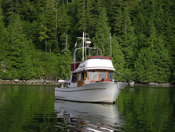
Morning after the storm at Crease Is. Cove. Looking NE.
About 0200 I got up because once again, not because of any storm or noise, rather it was just too quiet.  So quiet you could hear the water dripping off of the trees on shore.  I checked my anchor - all good.  I shone my spotlight about and I was still where I was supposed to be and there were no boats near me.  Except for the anchor lights of neighboring boats it was pitch black.  You could hear the the thunderstorm far off to the east and see purple, white, and magenta colors when the lightning lit up the clouds in the distance.  All was perfectly calm.  That's when I heard the hoot of a great horned owl on shore.  It was a melancholy huffing type of hoot.  The hairs on my neck immediately stood on end.  My imagination ran wild with native spirits running about in the woods.   I thought of the Thunder Bird, the suni qua (sp?), and more.  I quickly returned to the safety of my bunk and fell asleep listening to the dripping water and the hooting owl, only to wake later in the morning to again all quiet.  When I asked my family about the storm last night and they commented, "What storm?  What owl?"  I asked myself, "Was I dreaming?"  I looked for the Chris Craft and he was gone, in fact over half the boats anchored last night were gone.  Oh well, maybe I was dreaming.  If so what a dream.

We've returned to Crease Island Cove many times since that night.  It remains one of our most favorite anchorages on the BC Coast.  We very much enjoy cruising about and exploring the many small islands in our dinghy.  They're great for a nap, reading a book, or a picnic.  But, be careful there's black bears about.  I've got a great picture of my brother sitting on shore reading a book not knowing there was a black bear not more than 30' away from him.  He never knew until I told him later and showed him the picture.  Often times we have seen bears swimming from island to island, along with other animals - otters and raccoons.  We've seen orca and white-sided dolphins in Blackfish Sound and Knight Inlet.  There's great scuba diving too along these islands. (To learn more visit www.sunfundivers.com or Sunfun Divers on Facebook)  There's great salmon fishing nearby in Blackfish Sound.  Excellent prawning and crabbing nearby too.  Port McNeill is about 19 nautical miles away where you can stock up on provisions.  Or, you can easily wind your way through the islands to Echo Bay (~8 nm), just be careful of the currents and many shoals.  Being right at the southern tip of Queen Charlotte Strait and just by Johnstone Strait, Crease Island Cove is a great "jumping off" point for the trip home or for points further north.

Happy New Year!  May 2012 be a year filled with many safe and happy adventures.

Saturday, December 17, 2011

Favorite Anchorages: Jedediah Island Area

In previous posts, I have provided information on crossing Georgia Strait.  In this post I'm going to describe a few anchorages that I have come to depend on when we cruise up or down Georgia Strait.  If the weather permits we try to break up the long "slog" of crossing Georgia Strait into two days, otherwise it makes for a very long day.  One of our favorite stops is the "Bull Passage" area.  Bull Passage is formed by Lasqueti (pronounced "Laz-kee-tee") Island to the west, and Bull and Jedediah Islands to the east.  This little archipelago is not only a convenient stop-over but beautiful and unique too.
Click on image to enlarge

Lasqueti Island has quite a few homes on it - some vacation homes, some permanent residents.  Jedediah and Bull Islands are a BC Provincial Marine Park.  These islands are great for gunkholing about in a dinghy or runabout.  If you are a photographer or artist you will have hours and hours of items to photograph, sketch, or paint.   The rock walls combined with the reddish arbutus trees and lighting are so beautiful.  On Jedediah Island you can even find small cactus growing in small nooks and cracks within the rocks.  I found these cacti by painful accident while sitting one day.  You can even find some hiking trails about.  There's plenty of wildlife too.  There are feral sheep on Jedediah Island left over from long ago homesteaders.  We have seen otters, seals, and whales in the area.  Sheer and Rabbit Islands have nesting colonies of sea birds.  There's good salmon fishing nearby too.  Oh, one downside about this archipelago - it's mosquito heaven.  On all the anchorages we have been bothered by these little voracious biting beasts.

There are several anchorages in this archipelago each one with it's own advantages and disadvantages and qualities.  On the chart you will see Long Harbour but I avoid it because it is shoal.  Occasionally on some neap tides I have seen boats anchored in Long Hbr, but I never have.  Many of the small bays and nooks in the area are too deep, shoal too quickly by shore, or are too shallow.  As a result, I have experience with six (6) different anchorages in the Bull Passage/Jedediah Island area.  They are in order of my preference when anchoring in this area.
MV Independence at anchor in Boho Bay.
  1. Boho Bay.  This is a scenic and popular anchorage.  Anchoring depths vary from 40' to 60' feet on a hard mud bottom.  Holding is good.  I've seen as many as 6-8 boats anchored here.  There are some stern tie rings on the Lasqueti Island side.  Many boats anchor near Boho Island.  I use this anchorage in any kind of weather - NW or SE winds on the Strait.  The downside to this anchorage is that it can be popular and there is a research facility at the head of Boho Bay that has pump noises, lights, and small boat traffic.
  2. "Sheep Anchorage."  This anchorage has the name "sheep anchorage" because late in the evening the feral sheep on Jedediah Island will come down to the shore to graze.  It's interesting to be in your boat and hear the bleating of sheep nearby.  Commonly we have enjoyed incredibly beautiful sunsets from this anchorage.  Anchorage depths vary from 20' to 40' over a mud and gravel bottom.  Holding is good.  Few boats use this anchorage.  Once we had two other boats with us anchored here.  I only use this anchorage in calm weather or if a SE wind is blowing.  NW winds will make this anchorage a bumpy one.  Remember the winds in Georgia Strait often start to blow after midnight.  So in the evening you settle down to a calm anchorage only to wake a few hours later thinking you are in a washing machine.  Another downside to this anchorage are wakes from passing boats as they cruise Bull Passage.
  3. "Paul Island Cut."  This is a small and often crowded anchorage.  A stern tie to shore is required.  There are stern tie rings available.  Depths are 20' - 40' feet.  Holding good to fair.  This anchorage can get crowded and I generally avoid it.  I compare it to staying in a "trailer park."  It is scenic though.  Good protection in any kind of weather, though I get nervous in winds because of the closeness of neighboring boats even when stern tied.
  4. "Little Boho Bay."  This anchorage is seldom used and I only use it if the other anchorages are full.  Anchoring depths are around 40' on a gravel and rock bottom.  Holding is fair.  I only use this anchorage in calm weather.  The downside is the holding and the small research facility nearby.  A salt water pump to feed the fish tanks is located here and you will hear its motor running for most of the time - although it does shut down late at night.
  5. "Rabbit Island."  This anchorage located at the eastern end of the channel between Bull and Jedediah Islands and west of "Rabbit Island" is rarely used because of where it is located.  You have to be careful navigating the channel between Bull and Jedediah Island or coming from the Strait.  So, chances are you may be the only boat anchored here.  It is very beautiful with the steep rock walls and arbutus trees surrounding you on two sides.  Anchoring depths are around 20-30' over a mud and gravel bottom.  Holding is good to fair.  I only use this anchorage if a NW wind is blowing or in calm weather.
  6. "Always Taken Anchorage."  This anchorage is a one-boat anchorage in a small nook just off of Lasqueti Island.  It is quite protected in any kind of weather.  Good holding on a hard mud bottom in depths 20-30'.  The downside to this anchorage is that it seems to be always taken with another boat, hence the name.  Caution needs to be taken because there is a rock right in the middle of the anchorage entrance.  Once, another boater had to anchor here too giving me a restless night of "are we going to bump."  As a result I rarely use this anchorage.
Bull Passage is about 20 nautical miles from Departure Bay, Nanaimo and about 45 nautical miles to Lund via Malaspina Strait.  Or, about 34 nm via Sabine Channel (west side of Texada Island) to Lund.  It's about 55 nautical miles to Campbell River.  Commonly when cruising down Georgia Strait we will leave our anchorage in this area to get to Nanaimo before Area WG (Whiskey Golf) becomes active (listen to VHF Weather Radio 3).  Or, many times you will notice that Georgia Strait winds die down in the late afternoon and evening, so you can do the short cruise from Nanaimo to these anchorages and then get a good start towards Desolation Sound the next day.  Whichever way you go, I hope you try this great area out.
Sunset from "Sheep Anchorage"
To read previous posts about Georgia Strait and this area see:

Sunday, December 11, 2011

Favorite Eats: Navy Bean Stew - Boat Version

Cold days on the water call for something hot and hearty.  I really enjoy this boat version of Navy Bean Stew.  The whole idea of navy bean stew for me conjures up old sailing images of cruising New England's rocky shores, "Down East" boats, and places like Monhegan Island and Kittery.  It's simple and hearty fare of winter ingredients of mushrooms, beans, and greens.  Oh, and did I say bacon?  Everything tastes better with bacon.  The original version probably used salt pork, but I'll stick with bacon.  Let this stew slowly cook on your stove as you motor, under slow bell, to your anchorage and enjoy a winter's day cruising.  Nothing better than coming in to a warm cozy cabin, hot stew waiting, a good book, and family.  Or, you can do like me, just make the stew while sitting at the dock and puttering about your boat on a cold winter's day.

Now I call it a boat version, because although you make it from scratch you are using "victuals" found in your ship's larder.  The home version has fresh mushrooms, navy beans pre-soaked, and fresh greens like kale or spinach.  Sure you can pack some of these things down to your boat, but if you're like me, your larder is limited in size and you've got more canned food than fresh.  Sometimes the mood just strikes you for a meal that you have a hankerin' for, and you didn't leave the dock planning to make this meal; and you are too many miles away from any marina or store. Finally, you probably don't keep fresh ingredients on your boat in the winter months.

So let's get started... First, check your larder for the following ingredients:
  • Canned mushrooms, one large can or two small cans (If you have dried mushrooms like Shttakes, this is even better.  You'll want to soak enough to have about a good cup or more.)
  • Canned navy beans, one 15 oz. can
  • Canned spinach, one 15 oz. can (you can also use kale, fresh spinach, or bok choy about 2 cups)
  • Chicken broth, one can or 2 bullion cubes
  • Dried onions, 3 tablespoons (or 1 cup yellow onion diced)
  • Dried thyme, 1/2 teaspoon
  • 3 strips thick cut bacon, or some kielbasa sausage (you could use SPAM if needed, I have)
  • 1 tablespoon of ketchup (or if you are truly gourmet, a squeeze of tomato paste from a tube)
  • Canned potatoes, one 15 oz. can (or 3 small Yukon Gold or Yellow Finn's chopped)
  • Salt and pepper
  • 1 tablespoon of vegetable oil
  • 1 tablespoon of red wine vinegar (optional)
  • Fresh water, about 1-2 cups
Chop your bacon into small 1/4" pieces, or thinly slice your sausage.  Next, heat a large pot over medium-high heat with the vegetable oil.  Add your bacon or sausage and fry until the edges just start to get crisp but not burnt.  Add your dried onions or fresh if you have it and saute' for about a minute.  You just want the dried onions to "wake up" and start to get soft.  Add your canned mushrooms along with the water in the cans.  Add the ketchup and dried thyme seasoning too.  Mix well.  Drain the can of potatoes and chop them if you want.  Reduce the heat to low and next add the chicken broth, potatoes and water.  If you are using bullion cubes you'll want to add more water, if not about a cup of water will do.  Season this mix with salt and black pepper to your liking.  Let the mix cook over low heat, covered, for about 8 to 10 minutes or until the potatoes just start to get soft when poked with a fork. 

Drain the can of spinach, give the spinach a quick chop, and add to the pot - you can choose to add the entire can of spinach to the pot or just a portion.  Next you will want to thoroughly rinse the can of navy beans.  You don't want to add the bean liquid in the can to the stew.  If you do, it will make your delicious stew taste pretty "funky."  Once the beans are rinsed and drained, add them to the pot along with the vinegar, and let the stew slowly cook over low heat for about another 10 minutes.  Stir your stew occasionally during this time.  The potatoes will start to break down and thicken your stew.  If it gets too thick for your taste, add more water.  Just don't over cook your stew to the point where your beans start to break down.  The beans should always stay whole.

Finally ladle the hot stew into bowls top and serve with some crusty french bread.  If you're like me you'll add a bit of Louisiana style hot sauce to your stew to kick it up a notch.  A hot rum toddy goes good with it too.  Enjoy.

Variations: As a stew, you can always "fix 'er up" the way you want to.  I've added 1/2 cup of red or white wine right after adding the onions.  This will give it an even richer taste.  If you are a garlic lover, add fresh, dried, powder when you add the onions.  Do not use garlic salt, it will be too salty.  Do not use Bac-O's to get that bacon flavor - Ugh!  That will ruin it.

If you want the home version of the stew, drop me a note and I will either post it or e-mail it to you.

Saturday, December 3, 2011

Anchoring Hand Signals

Recently while on a trip down to check the MV Independence, a boat neighbor at the dock stopped me and asked about anchoring.  He said that many times he and his wife get into this shouting match because she's up at the bow dropping the anchor and he's running the boat.  She's screaming at him to do something, but with her back turned, and the sounds of the engines, he only hears "Bob, mumph, blah, blah, @&#%!"  He said he watched us come in to a local anchorage once, and how without a word, you calmly walked to the bow, your wife took the helm, and viola' you were anchored.  Never a word was heard between you two.  Of course my wife gave me a dirty look and said, "why can't we do that!"  He went on to comment that even when you dock your boat, even in trying conditions, you seem to have everything arranged and nary a word is said, and when a word is said, it's calm not shouting.

I offered him to come aboard, and share with me a finger of my favorite Canadian Rye.  I explained that after 22 years of successful boating and 32 years of successful marriage, we have come to develop some routines.  Otherwise, we would not be so successful in either boating or marriage.  There was a time when we too did the shouting routine, but found it just didn't work.   We anchor out 90% of the time when we go boating, so we had to come up with something.  It had to be simple, clear, and effective.  The idea of anchoring hand signals was born.  We've been using them for over 15 years now and they work great.  Letting my wife work the helm also gives her some experience working the boat.  And by me doing the anchoring I sleep better at night.  I then demonstrated and discussed with him each of the anchoring hand signals that we had developed.

The first three hand signals - forward, neutral and reverse - are pretty basic.  When you want to have the boat move forward, the arm from elbow up is raised and pointed up.  The boat will stay in gear going forward - at dead slow - until the another hand signal is given. When the arm is pointed straight out away from you and not moving, the boat should be taken out of gear into neutral.  Again, the boat is kept out of gear until another hand signal is given.  When the arm from the elbow is pointed down, the boat is put in reverse - at dead slow.  Although not pictured, if I want the speed increased, I simply spin my wrist in whatever position my arm is in.  If I want the speed decreased, I wave my fingers together in unison - making a flapping motion, like doing a child's wave.  To signal okay that the right speed is set, I simply flatten my hand.

If the boat needs to be turned, my wife and I worked out that the hand is spun in the direction you want the wheel to be turned.  My wife found that to be easiest and less confusing than pointing the direction, or saying "turn to port or starboard."  So, the arm from the elbow is spun to the right to turn right or starboard, and the arm from the elbow on down is spun to the left to turn left or to port.  Again, the helmsman performs the action until another hand signal is given.  One spin of the arm means just turn a little, whereas continuously spinning the arm means hard to the direction indicated. To indicate that the correct direction has been obtained, the arm is swung forward and back from its current position.

As said above, all actions by the helmsman are continued until another hand signal is given.  So we came up with these last two hand signals to indicate the action is over.  Waving an extended arm slightly up and down signifies that the anchor is set and no further action is necessary.  Waving the arm back and forth to above your head and back to level indicates that there is a problem.  When there is a problem the helmsman takes the boat out of gear immediately, comes forward to the bow to talk,  discusses the issue, and what the next actions are.

Again, the above system of hand signals works great for the captain and crew of the MV Independence.  Rarely, do we ever get into a shouting match and the boat is always successfully anchored.  We even use these hand signals when navigating through shoal areas or times when you need someone at the bow.  At the start of each boating season we rehearse the hand signals to ensure they are still understood.  We've found that having a crew that is coordinating with the skipper makes for easier and happier boating.  In the end trust and respect are maintained. You might even want to discuss with your crew the above hand signals or develop your own. 

At the end of the evening my boat neighbor and I had consumed more than one finger of whiskey and had invented a few other hand signals that might not be appropriate, but they sure did generate some laughs.
At anchor in Cutter Cove on a windy day.

Sunday, November 20, 2011

Farewell to a Favorite - Greenway Sound Marina

One of our favorite stops on the coast was Greenway Sound Marina.  A great place to meet friends, have a great meal, charge up your batteries, get water, get some supplies, do laundry, go on a hike, take a shower, and maybe even get a haircut. Yes, a haircut.  The red carpeted docks were there to greet you as well always a hearty "hello" from the owners Tom and Ann Taylor.  It "was" one of the best places on the coast.  That's right "was."  Greenway Sound Marina is no more.

I remember first stopping in at "Greenway" back in the early 90's.  We had just caught a large halibut and we needed a place to clean and package it that had plenty of electricity and water.  So we stopped in and we've never really left since - always stopping in year after year.  Back in the heyday of Greenway you had to call Tom on the VHF and make a reservation not only for supper but for moorage too.  You'd come around the point and you would see the place packed with all sorts of yachts - big luxury yachts, world cruising sailboats, trawlers, sailboats, and weekend cruisers.  You'd give Tom a 'shout' on the VHF and he'd always snuggle you in to the perfect spot with a hand.  When you got up to the store/restaurant to register you'd be greeted with a hug and a handshake by Ann and Tom.  Tom would then make your dinner reservation.  There wasn't too much time to chat as Tom was always attending to another boater, and Ann was prepping for dinner. Both Tom and Ann worked hard to deliver that renowned red carpet Greenway service.

Thursday, 7/20/2006, Day 8
            Woke to high clouds, a forecast for better or clearing weather and a return of afternoon northwesterly winds.  We pulled up anchor at 0955 and headed out.  Waters are perfectly calm under a high overcast sky.  We’re on our way to Greenway Sound Marine Resort for the night.  We went down Indian Passage, in to Fife Sound, round Notice Point in to Raleigh Passage, then in to Penphrase Passage, then Sharp Passage in to Sutlej Channel and finally in to Greenway Sound.  We pulled in to Greenway Sound Marine Resort about 1420.
            I hosed down the “Zipper” and the boat.  Then we went to set prawn traps over in Greenway Sound.  It is terribly hot out with very little wind to cool you down.  So motoring out to set prawn traps was some relief from the heat.  We had to re-set one trap because it was too deep and had drifted.  After setting the prawn traps we motored over to the Forest Service trailhead and took a hike to the lake.  The trail is deep in the woods and this too will serve as some relief from the heat.  We hiked to the ‘view point’ but it was overgrown with small alder trees.  Josef and I then took a quick dip in to the lake to cool off and refresh us.  It was deliciously cooling and refreshing.  After the hike, we returned to the marina, took showers and then had a wonderful dinner at the Greenway Sound restaurant.  You just can’t go wrong.  Josef and I really enjoy the New York steak with the Béarnaise dipping sauce. A fresh breeze from the S cooled the boat off later in the evening.

Sunset at Greenway Sound Marina
Come dinner time, the restaurant would be packed with all sorts of folks.  Conversation was easy and friendly.  Always a "Hi, we're from..." or "Oh, where are you off to now..."  Tom was an excellent host mixing wonderful drinks and always attending to any need you had.  Tom always had a great wine or drink recommendation. Waiting for dinner you could sit and look at the hundreds of yacht pennants that adorned the walls or gaze at the beautiful scenery from the restaurant.  When the meal came, it was not only delicious but a feast for your eyes too.  The food always looked delicious.  Ann was very particular that everything was perfect - and it was!  Always the freshest and best ingredients.  Once I had some visitors from Europe with me and they were amazed at the quality of the meal they had in the "wilderness."   I always ordered the Alberta beef New York steak because after a couple of weeks out on the boat all we ate was fish.  Tom seemed to have a connection with the heavens too, because glorious sunsets always seemed to accompany dinner.

Fishing right off the dock at Greenway
Our children enjoyed Greenway too.  They could fish right from the dock and catch big fish.  Once they caught a nice 20lb + ling cod right off the dock.  Or they would catch shiner perch and sell them to the other boaters as rockfish bait.  There was always something to do.  When suppertime came, we adults would enjoy a gourmet dinner, while Ann would make a delicious pizza for the boys to enjoy.  The kitchen staff even delivered to your boat!  The boys didn't mind that mom and dad were gone, they had power to watch a video and enjoy a pizza.  And, after they devoured the pizza they'd come for dessert.  Greenway had ice cream and all sorts of delicious desserts.

Sadly the demise of Greenway came slowly and from different directions.  One, the cost of fuel limited the number of boaters that wanted to travel that far.  Diesel fuel cost went from $0.50 per gallon to over two or even three dollars per gallon. Greenway was over 200 nautical miles from Seattle.  Two,  the economy made it tough to take the time off. Folks had to work versus taking time to travel.  To ease that, Tom kept Greenway technologically up to date adding WiFi and always working to ensure there was cell service.  He made connections with airlines to always offer daily service.  It was also hard getting good help.  Tom recruited the best help, but it was hard for the help to be so isolated.  Finally the bank didn't agree with Tom about a marina in the Canadian wilderness as an investment.  Three, the fishing and fishing regulations had changed.  Once it was easy to catch salmon and bottom fish, but then the stocks declined and the resulting regulations decreased the fishing opportunities.  And four, age.  Tom and Ann were getting older.  The demands of long days cooking and running a high-class restaurant took it's toll on Ann.  The Taylor's tried hard to find an owner that would continue to run Greenway with the quality they created.  That kind of quality is hard to find, and it just didn't work.  So last year Greenway closed.
Ann & Tom Taylor

I have closely worked with Tom and Ann for many years.  The Taylor's have seen my boys grow from youngsters to young men.  They have seen us grow old too.  I stay in touch with Tom, he's still energetic with new ideas as a twenty year old.  I wish I could match his youthful thinking, quick wit, and energy.  He just got a pacemaker installed and now he's back to prime form with a list of new ideas.  The Taylor's have many lifelong friends from all the years they welcomed boaters.  I would dare to say the Taylor's have a huge and extended family.  I am proud to count myself as part of their extended family.  I will miss Greenway Sound Marina.  I personally don't think another coastal marina will ever match what they had.  They were pioneers in the coastal marina business.

Sadly, the remote marina business is declining.  The past years have seen other quality remote marinas decline and close.  Again, costs to run a marina are not cheap, the season is short, and folks just don't want to take the time and cost to travel so far.  When you travel north, make plans to visit these remote marinas and enjoy a night or two and thank them for their commitment.  We try to stop every year at an "up coast" marina.  In some coming blog posts I'll write about some other marinas that we have enjoyed.  If you have some favorites, drop me a comment or an email at: capnnak@gmail.com

Saturday, November 12, 2011

Favorite Eats: Cincinnati Chili

As the weather forecast was predicting the first November storm with winds I thought it best to go down to the MV Independence and check things out - make sure the lines are tight, things are stowed away, and whatever else I notice.  The winds blew strong through the marina. You could hear the tell tale sounds of the wind with halyards slapping the masts, and squeaks of fenders as they were pressed against the dock.  Each gust would gently move the MV Independence slightly about in its slip, but I had no worries.  I decided to start the engine and let it run for awhile.  As usual it started right up and that brought a smile to my face.  I slowed the rpms to an idle and put the boat in gear.  The boat surged slightly forward but stopped as the mooring lines held tight.  I commented out loud and to myself, "I'll let you run for a while."  Now I no longer did I hear the sounds of the marina and wind, but the gentle purring of the motor.

While waiting for the engine to warm up, I poured my self a tot of whiskey, sat down, relaxed, and opened the MV Independence log book randomly to a page and began to read.  Like a bible I enjoy reading a past log entry and thinking about past travels and adventures, particularly on a stormy day.  Here's what I read...
5019.9 Monday, 8/25/2003, Day 35
Click on image to enlarge
Left Shoal Bay Marina at 0735.  Skies are heavy and gray as it rained most of the night.  At times heavily.  Now there only some light showers.  Seas are calm.  We made it through the Dent, Gillard, and Yuculta rapids fine, perhaps a bit early but there were no issues.  As usual there was a bunch of other boats going through too.  After the rapids we enjoyed a nice breakfast while continuing our cruise south.  We went through Desolation, passing our planned anchorage – Squirrel Cove at around noon. The boys and I were not in the mood to stop so soon.  The weather was still cold and gray.  Weather Canada was still predicting a SE storm. As we went S the weather seemed to get better.  Light winds were the name of the day.  We went down Thulin Passage, past Lund, and then we were considering staying at Westview/Powell River.  I called to see if the ice rink was open but it wasn’t.  So, we thought about it and then pressed on.  We considered staying in Blind Bay but it didn’t “jive” with the next day's plans of getting through Dodd Narrows at slack.  So we decided to press on to Pender Harbor.  I wasn’t too keen on paying for moorage at a marina so we are trying Bargain Bay which is south of Pender Harbor.  We’re anchored in 35’ at high tide.  Including us, there are 6 boats anchored in the bay.  When entering or exiting Bargain Bay you need to stay close to the East side to avoid a rock.  It’s very peaceful here it's like anchoring in a lake.  We had a nice dinner – Cincinnati Chili out on the aft deck.  Then we sat out and talked long into the evening.
Cincinnati Chili?  I almost forgot how good that is.  We learned about Cincinnati Chili from our good friends Tom & Ann Taylor at Greenway Sound Marina in the Broughtons where it was always on the menu. (Tom was originally from Cincinnati) His wife Ann made an incredibly delicious Cincinnati Chili. Cincinnati Chili is different from most chili recipes in that it some different spices in it and its served atop a pile of spaghetti with a big mound of cheese and onions if you so desire.  Unfortunately Greenway Sound Marina is closed but I'll provide you with a recipe so you can enjoy Cincinnati Chili.

I make two versions of Cincinnati Chili, a boat version - quick and easy, and a home slow cooked version.  Both are good and very hearty and comforting on cold days.  I mean what's not to like you got chili, cheese and pasta.  Here's the quick and easy boat version that we enjoyed that day in Bargain Bay.
  • 1 T vegetable oil
  • 1 yellow onion diced
  • 1 t garlic powder (or two cloves of garlic minced)
  • 1 can chili con carne with beans
  • 1 can diced tomatoes (I like Rotel - tomatoes with green chilis - if I have it)
  • 1 T dried oregano
  • 1 T cocoa powder
  • 2 t ground cinnamon
  • 2 t ground allspice
  • 1 t ground cumin
  • 1 t Worcestershire sauce
  • 2 t Tabasco or red pepper sauce
  • 1 T red wine vinegar
  • 2-3 cups cooked spaghetti
  • 1 cup grated cheddar cheese
  • Oyster crackers
 In a large pot over medium high heat add vegetable oil and get it hot.  Add about a quarter of the chopped onions (about 1/4 cup) and cook until onion is soft about 2-3 minutes.  Next add all the spices of cumin, cinnamon, allspice, oregano, and cocoa powder and saute them for about 1 minute with the onions.  Next reduce the heat to low, add the canned chili, canned diced tomatoes, vinegar, Tabasco sauce, and Worcestershire sauce.  Mix well and simmer over low heat for about 20 minutes to ensure that all the flavors develop. During this time you can also cook your spaghetti in boiling water with a touch of salt.

Place a good helping of cooked spaghetti in a bowl, ladle the chili over the top and ask, "You want a one top or a two top?"  If the reply is a "one top" put a big mound of grated cheddar cheese on top.  If the reply is a "two top" place diced onions on top of the mound of cheddar cheese.  The final "coup de grace" is a handful of oyster crackers on top.
Tip! What we do now, to avoid always having to take so many spices on board, we mix the dried spices - oregano, garlic powder, allspice, cinnamon, cocoa powder, and cumin - into a small Ziplock bag, label it, and put it aboard in the larder just in case we want Cincinnati Chili when out cruising. 
Hmmm?  As soon as I'm done here at the boat I think I'll go home and enjoy a big pot of Cincinnati Chili.  Just as I finished my tot of whiskey, I checked the engine and it was fully warmed up.  So I shut the engine down, gave the boat a last check, and quickly hurried down the dock through the wind and rain to get some Cincinnati Chili.  I know I'm going to have a "two top." Enjoy.

Saturday, November 5, 2011

Which Route Crossing Georgia Strait Is Best For You?

Last summer we took advantage of some very calm weather ahead of predicted stormy weather to come down Georgia Strait. Fuel cost, time, weather, scenery, and available anchorages all weighed in my decision on which "route" to travel down the Strait to Nanaimo. In the 21+ years I've been crossing Georgia Strait I've come to define three major routes that not only I but other boaters use. These are, west side, west Texada, and Malaspina. Each route has its benefits and its demerits. And along with each route there are some minor route changes that you can do. However, which main Georgia Strait route to use depends on where you are going, how much time you have, and the weather.

In my discussion on each cruising route, I will review each route based on the below criteria. Please note that the criteria below are based on my experiences and knowledge and may differ from others with similar knowledge and experience. Remember, you're the captain of your vessel and the below is only offered as advice that you may choose to use or not.
  • Distance from Nanaimo (Departure Bay) to a point where you technically out of any weather seas, e.g., Campbell River, or the southern end of Desolation Sound.  Although your numbers of nautical miles may vary, I will report the number of nautical miles from my log book from past trips. 
  • Weather seas. The potential for rough seas either northwest or southeast winds where you would experience "moderate" seas of 3'-4' or more. I will rate this from a "1" low risk to "5" high risk. I will further break it down into two sub-areas - Nanaimo to approximately Comox and that latitude across, and from Comox north.
  • Anchorages/Moorage. How many safe anchorages or marinas that are along the route and available if you were to experience heavy weather. Safe anchorages for me are where you can reliably be out of the winds and no worry of dragging anchor. I will list the number of anchorages and moorages that I would consider as safe. You may have your own favorite anchorages or marinas.
  • Popularity. The number of other boats that travel the same route. This can be both good and bad. I will list this as a "1" low (few boats travel this route) to "5" high (many boaters travel this route).
  • Hazards. Shoals, Area WG, ferries, shipping traffic, etc. I will rate this as a "1" low (few hazards) to "5" high (many hazards may be experienced).
  • Scenery. Views of shore, mountains, rock formations, and more while traveling. Again a scale will be used from "1" low (no scenic value) to "5" high (lots of scenery). This rating and criteria is pretty subjective and may vary from person to person.
  • Amenities. Places where you can stop for repairs or fuel, or provisions. A rating will be used from "1" low (few amenities) to "5" (lots of amenities).

Cruising routes for Georgia Strait. Click on image to enlarge.
West Side Georgia Strait Route.
Description: 

Follows the eastern shore of Vancouver Island.  Nanaimo to Denman Island (Lambert Channel) to Campbell River (Cape Mudge)
Distance:
73 nm
Weather seas:
southern end: 5  northern end: 5  average: 5
Anchorages:
4 (Schooner Cove, French Creek, Ford Cove, Baynes Sound/Comox)
Popularity:
4
Hazards:
1 (Ferry to Powell River, Shipping Traffic, unless you go into Comox then hazards would be a 4 because of shoals)
Scenery:
1 (May see orca in northern waters)
Amenities:
2 (French Creek, Comox)
Comments:
You’re pretty unprotected on this route and are mercy to the weather seas.  For me, it is a long and boring slog up the island.  However, if Campbell River is your goal then this is the route.  You can skip going up Lambert Channel and save about 5 nm.

West Texada (Sabine Channel) Georgia Strait Route.
Description: 
Nanaimo to Bull Passage, then up Sabine Channel along west side of Texada Island and then to Lund
Distance:
57 nm
Weather seas:
southern end: 3  northern end: 4  average: 3.5
Anchorages:
1 (Lasqueti/Jedediah Is.)
Popularity:
1
Hazards:
3 (Area WG, Mystery Reef, Shipping Traffic, Ferry to Powell River)
Scenery:
2 (Jedediah Is.)
Amenities:
1 (Lund)
Comments:
I do travel this route but only in good weather, it saves me a bit of time and we really enjoy Jedediah Marine Park.  Going up the west side of Texada is boring.

Malaspina Strait Georgia Strait Route.
Description: 
Nanaimo to Texada, then up Malaspina Strait to Powell River, then to Lund
Distance:
61 nm
Weather seas:
southern end: 3  northern end: 3  average: 3
Anchorages:
5 (Ballet Bay, Blind Bay, Garden Bay, Grief Point, Powell River)
Popularity:
5
Hazards:
3 (Area WG, Boating Traffic, Shipping Traffic, Ferry to Powell River)
Scenery:
3 (Forested shores of Texada, views of mountains)
Amenities:
5 (Garden Bay, Grief Point, Powell River, Lund )
Comments:
We travel this route the most, although I don’t often like the passing wakes from large powerboats.  We have seen bears along the shores of Texada Island.  You don’t feel alone on this route with all the other boats.  And, I’ve ducked into several different spots when I got tired of beating through the waves and swell.

Just SE of Lund
When crossing Georgia Strait I always listen to Comox Coast Guard Radio on WX 3 particularly for the weather “Georgia Strait – North of Nanaimo.”  They will tell me if Area WG (Whiskey Golf) is active and provide weather reports at the below locations to help me choose the best route.  The weather radio forecasts are updated at 4 AM, 10:30 AM, 4 PM, and 9:30 PM.  Automated weather stations are updated each hour.
  • Entrance Island – Lighthouse report
  •  Merry Island – Lighthouse report
  • Chrome Island – Lighthouse report
  • Cape Lazo – Lighthouse report
  • Cape Mudge – Lighthouse report
  • Ballenas Island – Automated report
  • Sisters Island – Automated report
  • Grief Point – Automated report
  • Sentry Shoal – Automated report
So there you have it my analysis of three cruising routes for Georgia Strait.  I hope this information helps you on deciding which route is best for you.  Again, it is based on 21+ years of experience crossing this inland sea which I call the “Monster.”  If you have any comments or suggestions I welcome them.  Happy cruise planning.

Saturday, October 22, 2011

Favorite Anchorages - Cullen Harbor, Queen Charlotte Strait

It's rainy, windy, fall mornings like this that have me dreaming of summer cruising both past and future.  As I sip my morning coffee I can imagine myself sitting in the MV Independence at some remote anchorage and watching the rain come down.  The image that many times comes to my mind is the anchorage at Cullen Harbor just at the entrance to Fife Sound at the far northeastern corner of Queen Charlotte Strait.  For all the anchorages between Puget Sound to Alaska this has got to be one of, if not my most favorite anchorage.  Oh so many memories of fishing nearby, playing in the tidal rapids in Booker Passage, exploring the many islands and bays, scuba diving, seeing wildlife - dolphins, whales, seal lions and bears, and meeting friends here.  How many times we said, "Let's just stay another day here."

Click on above to enlarge
Cullen Harbor is a great all weather anchorage.  Depths average around the harbor at 30'.  The bottom holding is good with a hard but pliable clay bottom with kelp that will really allow the flukes of your anchor to dig in.  I've never dragged anchor here.  The harbor has room for about 20 or more boats but I've never seen that many here.  It's especially well protected from any stormy SE winds.  We've hunkered down several times here to escape some pretty nasty blows.  If you want privacy there's a few little nooks you can anchor in.  If you really want privacy or protection you can anchor in nearby Booker Lagoon too.  No wind or swell will enter the lagoon.  And, not too many folks are willing to navigate Booker Passage to get into Booker Lagoon.  Traveling Booker Passage is easy during slack tide and you don't have to worry about any shoal water.  I've scuba dove the entire cut and the shallowest it gets is 40'.  There's four good anchoring areas within the lagoon, the prettiest being the far western bay.

inukshuk
Booker Lagoon offers great gunkholing for those days when the weather "outside" in Queen Charlotte Strait is nasty.  The lagoon gets filled with moon jellys during the summer.  We fully explored the many islands in and around the lagoon erecting inukshuks on them and searching for trinkets and treasures.  Some of the islands made for a great picnic spot or sunny spot to read a book.  We've done crabbing and shrimping in the lagoon too.  For many summers a pair of white-sided dolphins lived in the lagoon entertaining any visiting boater with jumps and tail dances.  We even snorkeled with the dolphins and that was an adventure that will live forever in our minds.  The dolphins would come at you out of nowhere and quickly turn just inches from you.  They would jump over you.  And sometimes would stop and hover close to your mask to get a good look at you.  It was fantastic.

Snorkeling in Booker Passage
If you're a scuba diver or a snorkeler, diving Cullen Harbor and Booker Passage is world class.  There's plenty of exotic underwater wildlife and things to see... Puget Sound King Crab, octopus, rock fish, basket stars, anemones, tube worms, kelp forests, and so much more.  Diving here is not to be forgotten, as it is one of the best dive sites on the west coast.  Many times you will see dive charters from nearby Port McNeill diving Booker Passage during slack tide. (Contact Sun Fun Divers in Port McNeill to book a charter)  When boating make sure to give them wide passage.

There's plenty of good fishing opportunities just outside of Cullen Harbor in Fife Sound.  Note that all of Cullen Harbor, Booker Lagoon, and the islands around Booker Passage are all protected as a Rockfish Conservation Area.  However the steep north and south shores along Fife Sound offer good fishing for ling cod and salmon.  Try trolling the tide rips that form at the entrance to Fife Sound and chances are you'll get coho or pink salmon when in season.  Early mornings trolling very slowly along the rocky steep  walls might even get you a nice sized Chinook salmon.  We've even caught halibut just outside of Cullen Harbor.  Large balls of herring or eulachon or pilchards will enter Cullen Harbor too.  Fish around these and you might get lucky with a big fish - we have.  If you want shrimp and prawns you'll need to travel farther down Fife Sound as the currents just outside of Cullen Harbor are too strong for good shrimping.  Although there's a few shrimp in Booker Lagoon.

Steller's sea lions just off of Screen Island in Fife Sound
For wildlife, many times you can find humpback whales just outside of Cullen Harbor.  Blackfish (small pilot whales) will enter Cullen Harbor to feed.  Just south of Cullen Harbor, across Fife Sound you will see a large rocky island (Screen Is.) that is popular with very large Steller's sea lions.  You can hear them barking and growling on quiet mornings while anchored in Cullen Harbor.  If you motor or kayak by this island you will see them swimming about, or sitting on the rock, or if lucky jumping off the rock and into the water.  The bulls weigh as much as 1,000 pounds and they'll make a huge splash when jumping in.  You can see killer whales in the area too.  One year, late in the season, we were entertained with hundreds of white-sided dolphins.  They were jumping, tail dancing, and splashing about just off of Eden Island.  It was quite the spectacle.  Of course you can always get a chance to see black bears.  If you are lucky you'll see them swimming from island to island looking for food.

Boys going exploring in Cullen Harbor
Finally one of the best features for my adventurous boys were to play in the tidal rapids in Booker Passage.  During large flood spring tides the current will create a large overfall and standing wave of about four feet and a subsequent whirlpool of about 10-15' in diameter.  If you have a dinghy with an 8 HP motor or larger you can safely navigate these tidal rapids.  I wouldn't try the rapids in the MV Independence though.  One year we had all of us in our dinghy and we couldn't make it out through the tidal rapids - the current was just too strong and it was not safe with the waves.  So we retreated to a small rocky island, had a snack, went beach combing, and waited three hours when the current was much less and then we easily made it back to the MV Independence anchored in Cullen Harbor.  But oh how the boys loved the adventure and the thrill, and it made for many long discussions of "how we were stranded and may never make it back."

If you need provisions Echo Bay is an easy 13 nautical miles away.  Port McNeill is about 25 nautical miles away.  You can use Cullen Harbor as a base to explore the many islands and bays around Eden, Mars, and Bonwick Islands just to the south of Cullen Harbor.

For me, Cullen Harbor and Booker Lagoon are small pieces of heaven on earth.  So many wonderful memories occurred in these places.  I think I'll take another sip of coffee, close my eyes, and enjoy the memories a little bit more.  Did I say it's raining, windy, and gray outside?

Want to read more about shrimping or crabbing or fishing?  Or cruising to the Broughtons?  Try visiting these previous blog posts:

Saturday, October 15, 2011

Summer Trip Planning - Going Beyond Cape Caution

I know it's fall and the summer cruising season is just over, but this is the time I start planning for next summer's cruising adventures.  There's a whole new experience of wilderness cruising called the "BC Central Coast."  This area stretches from Queen Charlotte Strait in the south to approximately Klemtu in the north.  It is an area that will provide cruising adventures for a lifetime.  There are several spectacular cruising areas within the Central Coast such as Rivers Inlet, Hakai Pass, Ocean Falls, Fjordland and more.  However to get to these dream cruising places you've got to cross Queen Charlotte Sound and go beyond Cape Caution.  This can be a significant cruising challenge for any boater - experienced or not.  You will have to deal with open ocean waves and swell, strong currents, and shoal areas.  Several times I have made this trip without any problem, but a few times the crew was seasick and about ready to mutiny.

Click on chart for larger image
There are two major routes to go beyond Cape Caution, one is to take the more direct route from Port Hardy, and the other is to follow the lee shore and go along the mainland coast.  The route from Port Hardy is shorter, more direct, and has less challenges of current and shoal areas, but is also more open to weather and provides few opportunities for shelter.  Once you leave the Goletas Channel area you are committed to go all the way.   I have done this and have spent several hours in very uncomfortable beam seas as the waves and swell came from the west and I'm traveling north.  I often jokingly say, "The only thing stopping the waves and swell here is Japan." Currently the crew does not like this route at all and will immediately object if I suggest it.  The other route by going along the mainland shore offers you more opportunities for shelter and less beam seas, but you have to deal with currents and shoals.  This is the preferred route that we normally take when going beyond Cape Caution.

Click on above chart for larger image
The planning for the mainland route crossing starts at Blunden Harbor which is a great all weather anchorage with excellent holding.  We've waited out several blows in this harbor.  There's plenty of exploring to do and there's good crabbing too.  To start planning for this crossing, listen to the weather forecast for the Central Coast from MacInnes Island to Pine Island.  You'll want to listen to lightstation weather reports at Pine Island and Egg Island along with the continuous reports from Herbert Island and West Sea Otter.  The lightstation reports and the weather buoy at West Sea Otter will give you an idea of the sea conditions of wave height and swell.  My suggestion is if the wind is anything greater than 15 knots and seas of three foot moderate or more, you're in for a rough and uncomfortable ride.  You will also want to consult the tide and current tables for Nakwakto Rapids.  Do not travel the "mainland route" during any kind of large ebb with winds over 15 knots.  If you do you will experience rough and steep seas particularly by the Jennette Islands, Slingsby Channel, and Egg Island.  I try to time my route during an early morning flood before the typical afternoon westerly and northwesterly winds pick up.  I recognize that I'll have to fight the current for a good long distance, but it will make for better seas and a happier crew.

Alternate route to anchorages
Once you go around the Jennette Islands you will immediately feel the waves and swell from Queen Charlotte Sound if the winds are from the west or northwest.  One year we were happily cruising along fighting a two foot chop and "wham" we went to steep four foot seas or more almost as soon as we passed the light on Jennette Island.  The crew was not happy and we immediately made for one of two good anchoring refuges - Skull Cove or Miles Inlet.  Both of these anchorages offer good protection from weather and offer good holding.  Miles Inlet will provide anchorage for about four boats, whereas Skull Cove will offer anchoring for dozens of boats.  If the seas are particularly rough you can take a alternate route to Skull Cove which will take you out of the rough water sooner.  One year the westerly winds never let up and we never went around Cape Caution instead staying at Skull Cove and exploring the islands of the Murray Labyrinth and going into Seymour and Belize Inlets.  We had good crabbing, good fishing, and lots of exploring.  It turned out to be one of our best trips ever.

Once you get past Cape Caution stay well to port of Egg Island and Dugout Rocks.  At this point in your crossing if there are any kind of westerly winds you will probably be beam to the waves and swell.  Once you pass Dugout Rocks you can put the prevailing westerlies to your port stern quarter and start to ride the waves and swells into Rivers Inlet and stay at Duncanby Landing or farther in to Dawsons Landing, or go on to our favorite anchorage Fury Cove.  If you experience rough beam seas by Egg Island and had enough that, you can always turn into Smith Sound and go exploring there too.  There's plenty of excellent anchorages and things to do there too.

Be prepared.  As far as cruising essentials you will want to make sure you have any spare parts that you might need and make sure your boat is in perfect operating condition. Make sure to top off your fuel and water tanks. The marinas are far and few between beyond Cape Caution.  Make sure you have the paper charts you need; don't just rely on electronic charts. Take the time to study the charts before you go so you'll have a plan if the weather turns sour.  Check with your marine insurance provider - many insurance policies only go as far as Hope Island at the end of Goletas Channel.  You may need to pay for extra insurance or get a waiver. Finally make sure your radar is working - chances are you will need it.  June is typically wet with low clouds. July is typically windy particularly in the afternoons and evenings.  And August is known locally as "Fogust" with strong afternoon winds after the fog lifts.

Cruising beyond Cape Caution provides you some of the world's best cruising opportunities as well as incredible fishing for salmon, halibut, and bottom fish.  The wildlife viewing opportunities are rich too - wolves, bears, whales, dolphins, and more.  And finally if you want that remote scenic anchorage all to yourself there's plenty of them to be found.  Hope this helps.


MV Independence at anchor in Fury Cove
Interested in other "summer trip planning" posts?  You might want to search the MV Independence blog for:

Sunday, October 9, 2011

Favorite Anchorages - Turnbull Cove, Grappler Sound

One of my favorite anchorages when visiting the Broughton Archipelago is Turnbull Cove at the far northern end of Grappler Sound.  For me it is one of those anchorages where you can truly sit back and relax.  It's a quiet anchorage where you can hear the rain dripping off of the trees after a rain, the sounds of birds in the woods, quite simply it is a place where you can do some meditation.  However, there's lots to see and do if you are adventurous.

Click on image to enlarge
Calm before the storm in Turnbull Cove
Getting to Turnbull Cove is easy and there are no navigational hazards.  You travel up Grappler Sound, around Watson Point, through the narrows between Watson Island and the mainland, and turn to port into beautiful Turnbull Cove.  Currents will reach up to 5 knots by Watson Point and through the narrows, but there are no rapids.  Turnbull Cove is very protected from any kind of weather.  It can be stormy out in Queen Charlotte Strait and you'll barely notice the winds in Turnbull Cove.  Once we waited out quite a blow here and barely experienced a ripple.  The hard mud bottom has good holding all around.  I like to anchor in the western side of the bay in about 30-40' of water. 

At the far northern end of Turnbull Cove you can hike to Huaskin Lake - look for the collection of pilings and the BC Provincial Parks trail head sign.  It's not much of a trail, a simple straight up trail up the old logging shoot.  You can see the old cables left over from logging.  It's just shy of about a half mile hike - no switchbacks just straight up the hill.  Once you get to the top you will drop down a staircase to Huaskin Lake where there's a rustic dock and picnic table.  A few adventurous types I know have lugged a kayak up to the lake and did some fishing for trout.  You can also go hiking on the many logging roads nearby.

Roaringhole Rapids
A very fun side trip is to go to Roaringhole Rapids which is the entrance to Nepah Lagoon.  Foam from the rapids when ebbing can often be seen as far away as Watson Point.  Once we entered Nepah Lagoon at the end of flood and traveled a mile or so in but I got worried about getting stuck inside of Nepah Lagoon and so we left quickly.  Inside of Nepah Lagoon it seemed like a very wild and pristine place.

Another fun trip is to circumnavigate Watson Island.  It's an easy and scenic trip even by dinghy.  You start by going through beautiful Kenneth Passage with its many small islands, going around Claypole Point which to me seems to jut out like the giant bow of a ship, and then down through Hopetown Passage and Hoy Bay.  Hopetown Passage gets very shallow so you'll have to watch it.  One year we saw a large yacht grounded in Hopetown Passage - not sure what they were thinking by going through it.  After going through Hopetown Passage you make your way back into Grappler Sound.  If you travel on a flood with the exception of Hopetown Passage you'll get pushed all the way.  If the current is ebbing you can also see the rapids by Overflow Basin as you make your way back to Turnbull Cove.

If you're into fishing, shrimping and crabbing, there's plenty around.  We've caught halibut in Grappler Sound, caught lingcod and yelloweye rockfish nearby, got crab in nearby Burly Bay, and shrimping in plenty of different spots around Turnbull Cove and Mackenzie Sound.  We didn't get too many Spot prawns but always got lots of the smaller Coon Stripes.  Note that Kenneth Passage and the entrance to Nepah Lagoon is a rockfish conservation area.  If you're into wildlife watching keep an eye out on shore during low tide there's a good chance you'll see black bears on the beach. Once I counted over 7 black bears at the same time on the beach in Turnbull Cove. If you travel to the head of Mackenzie Sound or into Nimmo Bay you may be able to see a grizzly.   In Kenneth Passage and down Mackenzie Sound there's lots of waterfowl to see.

If you need to re-supply on groceries or fuel, or want to eat out you can visit nearby Sullivan Bay about 7 nautical miles away.  Port McNeill is about 27 nautical miles away.

I hope you visit Turnbull Cove and enjoy it as much as I do.  It is one of my most favorite places on the entire BC coast.