Happy New Year! Now that it is 2012 it's time to start planning your cruising adventures. What do you need to have to start planning a successful cruise? Here's my list of essentials:

- Tide and Currents book for 2012. For me the absolute best is "Ports And Passes." I will use a highlighter to mark those tides/currents that are important for me. Every year I attend the boat show to pick up the latest copy.
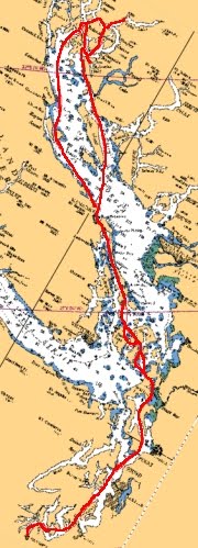
- Paper charts - at least I start to make notations on them, pencil in compass headings, mark caution areas, mark anchorages, and fishing spots - prawning, crabbing, bottom fishing, or salmon. A paper chart will rarely fail you.
- Electronic charting software - I really like "Navionics." I can use this to get distance and compass heading data on my Android tablet.
- Electronic current software - I like "Currents" by Yoyana for my Android tablet. It has current data from Olympia, WA to Hope Island, BC. The BC current data is not as rich as the US current data. I refer to this to get "up-to-the-minute" information on what the currents will be where I am cruising. Such as, am I fighting a current and how much, or am I going "downhill" and how much am I getting pushed?
- An electronic spreadsheet. I make a list of cruising routes and alternatives, waypoints, events (slack tide), miles, departure and arrival times, estimated speed, and time for each day cruising. My whole itinerary is in the spreadsheet. Then I can do "what if" planning by changing the time or speed for a location I can see how it will affect the rest of my trip. I can also refer to past years.

Optionally, I will also use some cruising guides and Internet tools to understand what the current status is of marinas and locations (restaurants/bars, repair facilities, stores, etc.). Here are some of my favorites:
Based on all of the above information, the next and foremost thing I start looking for is favorable tides and currents. I plan my trip around this information and then request the days off for my trip. The tides and currents can also dictate where I will go and for how long. The last two years we have cruised to Desolation Sound and not gone further north because of balancing our time with tides and currents. Considering the cost of diesel fuel these days, I believe you very much need to consider how you can take advantage of the the tides and currents to push you along. Last year taking advantage of tides and currents I was able to reduce my RPMs, travel at nearly the same speed, and save lots of money. I cruised at an incredible 1.38 GPH! I saved over 0.4 gallons per hour using the tides and currents - that's
$1.56 of diesel fuel every hour.
For me, I have six major tide and current areas that I have to watch - not only for the cruise up but for the return cruise too. Depending on the tides and currents they may dictate which route I cruise. These current areas are:
- South Puget Sound - from Olympia to Seattle (Dana Passage, Balch Passage, Tacoma Narrows)
- North Puget Sound - from Seattle to the Canadian Gulf Islands (Central Puget Sound, Admiralty Inlet, Deception Pass, Rosario Strait, San Juan Channel, Haro Strait)
- North Gulf Islands - from Montague Harbor to Nanaimo (Dodd Narrows, Porlier Pass)
- Georgia Strait - from Nanaimo to Desolation Sound. Although the currents are not that strong, any little bit helps and the currents combined with the weather can make for uncomfortable cruising.
- Desolation Sound - from the Yucultas to Johnstone Strait (Yucultas - Yuculta, Gillard, & Dent rapids, Greene Point, Whirlpool, Discovery & Seymore Narrows, Upper & Lower Rapids)
- Johnstone Strait & Blackfish Sound (Johnstone Strait, Weynton Passage, Chatham Narrows)
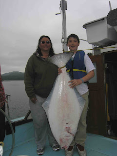
Finally as I have mentioned in previous posts, the tides and currents will dictate where and when I want to fish for what. For example, no use halibut fishing on Taylor Bank in Queen Charlotte Strait when there is a good flood or ebb, you won't be able to hit bottom or stay on location. Also there's a good chance you'll lose a lot of bait and gear. I look for a neap tide to fish here. If there are none, I'll aim for a slack tide. I like to go "
catching" versus fishing.

So when do I believe are favorable days based on tides and currents to head north?
For Puget Sound (South & North): June 4-5, 18-19; July 2-3, 19-20; Aug. 4-5 (
Ride the ebb currents all the way to Friday Harbor.)
Desolation Sound: June 23-24; July 23-24; Aug. 21-23 (
Early morning slack at the Yuculta's then ride the ebb all the way through Greene Pt Rapids, Whirlpool Rapids and Johnstone Strait.)
Fishing for halibut? July 11 (PM), 27 (PM); Aug. 10 (PM). (
Unfortunately the prevailing northwest winds tend to kick up in the afternoons, so halibut fishing might not be so lucky this year.)
Hope this helps your 2012 summer cruise planning. If you got questions or comments, leave a comment or email me. In Part 2 of Summer Trip Planning I will discuss routes, anchorages, customs. In Part 3, I will write about getting your boat ready for a trip. In Part 4, provisioning. Again, if you have helpful tips or comments, let me know. Happy Planning!
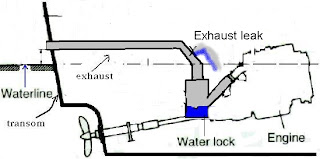
 In hindsight I and the MV Independence were lucky. Investigation taught me that exhaust hose lasts about 10 years, and metal exhaust elbows about 4-6 years. The exhaust system is a highly corrosive system that contains hot seawater and exhaust and it deserves annual inspection. Now as part of my spring routine I take a ball-peen hammer and pound hard on the exhaust system every 2-3" from the engine manifold all the way to the stern. The hammer should "bounce" off the hose and make a high pitched sound on any fiberglass items (exhaust elbow, water muffler, etc.) and metal items. Any "thud" or reduced bounce gets extra attention. Besides hammering the hose and fittings, I look for any sort of "salt weep," rust, or discoloration. I make sure I have some stiff aluminum sleeves available, plenty of duct tape, Marine Tex epoxy, a big mat of fiberglass, and epoxy resin so I can make emergency repairs. Oh, and I always make sure I have a few cans of beer.


