Sunday, April 24, 2011

Destination: "The Broughton's"

One of the best cruising destinations on this earth for me is the Broughton archipelago, or simply known as the Broughton's.  These islands at the far east end of Queen Charlotte Strait are simply wonderful to explore and get lost within them.  The scenery varies from low lying wind swept islands to beautiful mountain scenery.  You can find popular anchorages that serve many boats to very private anchorages that you can have all to yourself.  The wildlife is quite varied and abundant - seals, orca, bear, deer, seabirds, eagles, ravens, and more.  If you're into history the area is quite rich with native history, explorations by Capt. Vancouver, logging, fishing, and those that want to get away from it all.  It simply is for me paradise.
Click to expand

Of course one of the reasons to go to the Broughtons is for seafood.  You can find good salmon fishing here - chinook, coho, and pinks.  You can find good bottom fishing here for halibut, ling cod, and yelloweye rockfish (red snapper) and more.  Much of the area is protected by Rockfish Conservation Areas (RCAs) so you will need to consult a DFO pamphlet prior to fishing.  There's wonderful shrimping to be found in many of the inlets, and if you're a scuba diver you can get rock scallops too.  There are many incredible scuba diving locations.  Some of the best scuba diving on the planet can be found here.  If you're interested in scuba diving check out my good friend Steve Lacasse from Sun Fun Divers in Port McNeill.

If going for a walk is also part of your adventure there's plenty of hikes to be had too.  In Greenway Sound you can hike up to Broughton lake for a refreshing swim.  The BC Forest Service has several established areas for hiking at Turnbull Cove, Moore Bay, and Greenway Sound.  We have also simply hiked on the many abandoned logging roads for a refreshing hike - just stay away from active logging areas.

If you're into learning about the area's history, a stop in Alert Bay to visit the U'mista Cultural Museum is a must.  You can visit other native sites such as Mamalilaculla, Karlukwees, Matilpi, and Heath Bay but remember these sites are private property and must be treated with absolute respect.  If in doubt ask for permission to visit these locations.  Often a guide will be present to tell you about the area.  If you look hard you can find pictographs on the rocks of Vancouver's long ago visit in some remote bays.

Here's some of our favorite spots:
Click to expand
  1. Carriden Bay, Grappler Sound
  2. Crease Island, Village Islands Group, Knight Inlet
  3. Baker Island Bight, Fife Sound
  4. Joe Cove, Eden Island, Fife Sound
  5. Prawns from Kingcome Inlet
  6. Indian Passage, Fife Sound
  7. Turnbull Cove, Grappler Sound
  8. Spring Passage
  9. Cullen Harbor, Fife Sound
We've been traveling to the Broughtons for 20+ years and still have never anchored or visited every spot.  I have found that there's something new to be found almost every time we've visited the area.  If you're going to make the Broughton's your destination, know that June can be rainy & cold, July can be nice but windy, and August is known as "Fogust."  Generally the weather pattern is for calm mornings with afternoon northwestern winds of 15-25 knots.  Of course the farther you go into the inlets the calmer the weather will be.

If you're going to visit the Broughton's I suggest you make Port McNeill your base.  There's a great marina there, groceries, fuel, and supplies to be had.  It's about 4 hours drive by car from Nanaimo if you plan to have guests visit you.  Many float planes service Port McNeill and the area from Seattle and Vancouver.  Might I suggest that from Port McNeill you make a "circle route" to do your Broughton's exploration. You will need CHS Charts 3547 & 3515. Start by visiting the islands in and around Blackfish Sound & the Village Group, then cross Knight Inlet into the Baker-Insect-Eden Island archipelago by Fife Sound, then to the Burdwood Group & Fife Sound, then to Sutlej Channel going up to Grappler Sound & the many anchorages there, and finally out Wells Passage crossing Queen Charlotte Strait ending at Port McNeill.  We've done this "circle route" many, many times.  Future posts will describe some of the above locations and anchorages in greater detail.  If you have questions regarding the above area, don't be afraid to leave a comment and I will try to respond.

We enjoy fresh caught rockfish (Quillback, Black, Copper, etc.) a lot.   Here's a favorite MV Independence recipe we invented over the many years while cruising in the Broughton's.  We call this dish, "Rockfish Mediterranee."  I hope you enjoy it as much as we do.

Ingredients:
  • 2-4 rockfish fillets
  • 2 tbsp butter
  • 2 tbsp onion, chopped
  • 1 tsp garlic, chopped
  • 1 cup tomato chopped
  • 1 tbsp capers
  • 3 tbsp green olives with pimentos, sliced
  • 1 tsp dried oregano
  • 1 tsp dried basil
  • 1 tsp lemon juice
  • 2 tbsp sweet vermouth or Japanese mirin
  • 1 tsp Cajun seasoning
  • 4 cups cooked pasta
Heat skillet with butter over medium heat, add onion and garlic and cook 3-5 minutes until onions are soft.  Add tomato, capers, green olives, herbs, lemon juice and vermouth.  Let this cook for 5 to 6 minutes, stirring occasionally.  Reduce the heat to low.  Lightly pat the fish fillets with the Cajun seasoning and place the fish fillets on top of the tomato mixture, cover and let the fish steam for 5-7 minutes.  Serve fish and sauce over top of cooked pasta.  Add salt & pepper to taste.  Enjoy.

Wednesday, April 13, 2011

Favorite Anchorages - Beaver Inlet, Loughborough Inlet

A great, not too popular anchorage that is north of Desolation Sound is Beaver Inlet.  Beaver Inlet is a small inlet that extends west off of the much larger and very scenic Loughborough Inlet.  It's a "bomb-proof" anchorage that's just off of the beaten waterborne path of Chancellor Channel.  My opinion is that it is very scenic, plus it offers some good opportunities for getting seafood - particularly crab and shrimp.  We used it one year as a cruising destination because we didn't have as much time to go farther north.  It offered us some isolation (which I like), a good safe anchorage, and plenty of daytime opportunities for fishing and exploring.

Click to see full image.
Loughborough Inlet is about 18 nm miles long.  As you work your way up the inlet the mountains rise steeply on either side of the inlet.  Like most BC fjords the inlet terminates where a river enters and the waters are shoal and milky and depths are hard to determine.  There's not too many other anchoring opportunities for Loughborough Inlet since small bays of Sidney, Heydah, and Frazer are too deep for safe anchoring.  Where you do find a decent anchorage depth you will find yourself possibly swinging in to shore.  There's also a lot of logging going on in Loughborough Inlet.

View of Franklyn Range from Beaver Inlet anchorage.
Beaver Inlet is about 4 nm miles from start of Loughborough Inlet from Chancellor Channel.  Beaver Inlet itself is about 3 nm in length.  On the south side of Beaver Inlet there are some very scenic mountains of the Franklyn Range.  On the north side of the inlet there are some lower lying hills.  From the end of Beaver Inlet it is only about 3 miles (as the crow flies) from the end of Forward Harbor to the west.  When anchored near the end of Beaver Inlet you can look up the inlet and see snowy tops of the Pembroke Range.

The holding in Beaver Inlet is excellent in thick clay/mud in depths about 30-40'.  Once while anchored here a storm blew through and we probably had a few gusts of 30 knots or more and never moved an inch.  The weather radio reported storm force winds in Johnstone Strait of 50 knots or more.  Some westerly winds will enter through the low lying area from Forward Harbor to the west.  However, I welcome these winds as they keep the bugs (horseflies & mosquitoes) in the woods and keep us cool on hot days.  There's plenty of anchoring space in Beaver Inlet so even if there are other boats anchored you can still feel alone at your anchoring spot.

Crabbing can be good in Beaver Inlet, but occasionally a commercial crabber will set their pots in the Inlet too.  Also there are some year-round residents in Sidney Harbor just north of Beaver Inlet and in the area that will set pots here too.  A fish biologist friend of mine recently did an underwater survey for the Department of Fisheries and Oceans (DFO) and was amazed at the number of young juvenile Dungeness crab he found here.  But again, crabbing can be spotty from year to year.  One year instead of setting pots I simply paid the commercial crabber for some crabs.  I believe I got an incredible deal of big fresh Dungeness crab, helped the local economy, and made another coastal friend.

Nice big spot shrimp from Loughborough.
Shrimping can be excellent in Loughborough Inlet.  In fact, Loughborough is known for its spot shrimp.  You can set shrimp pots almost anywhere and get some shrimp. Once we set one shrimp pot and got well over 100 spot shrimp all over 5" long.  Not more than 100 yards away the other pot had maybe 60 coon stripe shrimp.  Who knows, the bait and depth were the same.  Just be aware that the current does run through Loughborough Inlet which can greatly affect the number of shrimp you might get (see previous post on catching shrimp).  Also, Loughborough Inlet is popular with commercial shrimpers which may also affect how many shrimp you catch.  If setting and retrieving shrimp pots is not your thing, a resident in Sidney Bay will sell you local caught Loughborough Inlet shrimp.

You can also use Beaver Inlet as a base camp for exploring Loughborough Inlet.  We have dinghy explored Sidney Bay to the north as well as some small islands and bays on the east side of Loughborough Inlet.  We found some absolutely gorgeous spots filled with beautiful wildflowers.  We've seen mink and martens, otters, as well as a few bears in the area.  The past few years I've noticed a pair of nesting bald eagles in Beaver Inlet.  You will also see quite a few homes that are either summer residences or a few permanent residences.  Some buildings are "ghost houses" that probably told of better times.  Finally Blind Channel Marina is about 12 nm miles away if you need any crucial fuel, groceries, or liquor.  All in all I believe you will find Beaver Inlet and Loughborough Inlet a fun stop on your exploration of the BC coast.

Because of the shrimp bounty we have experienced in Loughborough Inlet I'll share with you one of my favorite recipes that's sure to be a hit when you raft up with a bunch of friends - Shrimp & Sausage Gumbo.  I also always make my own Cajun seasoning prior to leaving on a trip.

Cajun seasoning:
  • 1/4 tsp ground white pepper
  • 1/4 tsp onion powder
  • 1/4 tsp ground thyme
  • 1/2 tsp cayenne pepper
  • 1/2 tsp ground black pepper
  • 1 tsp salt
Gumbo ingredients:
  • 1/4 cup vegetable oil
  • 1/4 cup flour
  • 1/2 yellow onion, chopped
  • 2 stalks of celery, chopped
  • 1 green bell pepper, chopped
  • 2-3 cloves garlic, finely chopped
  • 1/2 lb. Andouille sausage or whatever you have on board (could even be canned chicken)
  • 2-3 chicken bullion cubes
  • 4 cups water
  • 1 can diced or crushed tomatoes
  • 1 can okra, drained
  • 2 3/4 tsp of cajun seasoning 
  • 1 Tblsp of dried parsley
  • 12-16 medium sized shrimp tails, peeled
  • 3 cups cooked rice
Method:
  1. Chop all vegetables in advance, pre-open cans, and have all ingredients ready.
  2. Make a roux.  Pour vegetable oil into a heavy pot and over high heat, heat oil until shimmering.  Add flour and continue to stir until oil-flour mixture looks the color of melted chocolate - a deep, dark, rich brown.  Important thing here is to continuously stir the oil flour mix.  If needed add more oil to make smooth.  This will take about 2-3 minutes.
  3. Add chopped onion, celery, and green pepper to the roux and mix well.  As soon as the vegetables start to get soft (about 2-3 minutes) add sausage.  Again stir frequently until meat just begins to brown (about 3-5 minutes).
  4. Reduce heat to low, and add canned tomatoes, okra, bullion cubes, water and Cajun seasoning.  Stir well and let simmer, covered for about 30 minutes or so.
  5. Turn off the heat, add shrimp, dried parsley, mix well and cover and let stand for 5 minutes.  Meanwhile put a scoop of rice in a bowl and when ready ladle hot gumbo over rice and serve with plenty of Louisiana hot sauce.  Enjoy.

Sunday, April 10, 2011

New Batteries!

The time had finally come to replace the dead and dying batteries in the MV Independence.  The MV Independence has 3 8D batteries.  One that is used primarily for starting, and two that are used for the house, but can be used for starting too.  The dread is getting these behemoth batteries out of the engine room.  The MV Independence does not have a "stand up" engine room, rather like a lot of boats a "kneeling" engine room.

First step is that prior to removing the wires attached to each battery I made sure that I had them adequately labeled which wire went to which battery.  I know my current configuration is a mess and not satisfactory, but I will clean it up.  It's been this way for 20+ years and the wiring will get organized.

Next was removing each battery from the engine room.  The MV Independence is configured that the engine hatch that provides access to the engine room is almost directly over the batteries.  Generally when you stand in the engine room before dropping down and kneeling in, you are doing this on top of the battery box.  So to get the batteries out requires some thought on where are you going to stand.  The engine room hatch is approximately 30" square.  The batteries are seated deep in a battery box and the distance from the base of the battery box to the main deck is just over four feet.  Consider that each battery weighs over 130 lbs!  After considerable discussion we decided this, one would stand in the engine room and get that initial lift to where a second person kneeling on the main deck could grab the other handle and together lift the battery out of the engine room.  This ended up working pretty good.  We also decided that we would remove each battery - one at a time - from the boat to the dock cart.  Each step - from deck to doorway, doorway to gunnel, gunnel to finger pier, finger pier to dock cart was carefully scripted and done.  This procedure was repeated two more times successfully.  Finally all the batteries were out of the MV Independence.

I carefully scripted the timing of the removal of the batteries with the tide.  What? Yes, you don't want to end up pushing almost 400 lbs. of batteries up a steep ramp from the dock to the land.  Especially in Olympia where you might have a 14' low tide.  I timed our removal for high tide and moving the batteries from the dock to shore was easy.  However, by the time we would replace the batteries the tide was going to be low, so we would have to deal with a steep ramp but going down is easier than up.

I decided to purchase the new batteries at Pacific Power Batteries in Everett.  Yes, this is a long drive from Olympia to Everett, but the savings in the purchase price would more than make up for the gas.  Pacific Power Batteries uses Exide batteries which are good quality batteries.  Additionally, they have excellent customer service and know a lot about batteries.  I purchased a starting battery and two deep cycle batteries, again all 8D sized batteries. The guys at Pacific Power Batteries were amazed that I had gotten eight years out of Sears Die Hard batteries.  Sears Die Hard batteries don't have a good battery reputation.  If you need batteries I would highly recommend Pacific Power Batteries.

After the drive up and back, along with a stop in Seattle for lunch - dim sum.  It was now time to do the reverse - put the batteries in the boat.  First of all the tide was low, it was a 0' tide and the ramp from shore to dock was steep.  We had four people help, two pushing against the cart, and two holding the cart back as we slowly went down the steep ramp.  I could just imagine the cart flying down the ramp and off the end of the dock and 400 lbs of batteries into the bay.  Fortunately this was not the case.  Again, we did everything in step-wise fashion from dock cart to engine room.  It was much easier installing the batteries than removing them.  I simply made some battery connections but didn't do all the connections since I promised I was going to do it right this time.  That's coming next.  For now I was happy enough to know that the job was complete and hopefully would not need to be done again for at least five years.

What's next?  Time for a haul-out.

Wednesday, April 6, 2011

Favorite Anchorages - Cordero Islands Cove

One of my favorite anchorages north of Desolation Sound is "Cordero Islands Cove."  I don't believe this is the established name, because on the charts the small cove is unnamed, but it's what I call this little gem of an anchorage.  It's kind of like anchoring near a river; in the early morning or late evening when things begin to quiet down you can hear the nearby Greene Point Rapids.
Not to be used for navigation

There's good holding of grey clay/thick mud and kelp.  I've never had any challenges here with setting an anchor.  The current does move through the cove and will help you keep your anchor set.  It's well sheltered from the westerly winds that blow down Chancellor Channel.  You'll get enough of a breeze to cool you down on hot days when it's blowing a gale in Johnstone Strait.  Once we waited here a couple of days to avoid a big blow in Johnstone Strait.  The cove is also sheltered from the wakes of the many passing boats that travel by in Cordero channel.  At times I've seen as many as six boats anchored here and maybe that's getting close to the limit.  It's not a big anchorage.  You'll want to anchor early in the afternoon before the anchorage fills up.  Anchoring depths vary from 60' to 30' at high tide.  There's only one way to enter the cove and that is between the two larger islands east of Greene Point Rapids marked "59" and "37" on the chart.  There is some kelp in the entrance and you'll want to stay west of that.  Do not try to enter from the eastern end of the cove as there are a lot of rocks and shoals.

Blind Channel Marina is about 2 nm south of the anchorage and Cordero Lodge is about 2 nm east.  Both are easy dinghy trips, but note there are some strong currents to get to either location so I'd recommend a good reliable motor on your dinghy.  Blind Channel Marina has a full store and restaurant (you'll need to call ahead to make reservations).  You can get fresh bread, groceries, vegetables, liquor, and souvenirs at Blind Channel Marina.  You can also go on a nice hike to visit the "big cedar tree" by Blind Channel.  Or, you can enjoy a wonderful Schnitzel or other German cuisine at Cordero Lodge.  Again, call ahead for reservations.  It's also fun to explore by dinghy the many islands that are at the western end of the cove.  The island marked "37" has a nice flat, smooth beach rock at the western end of the island for sun bathing and watching boats go by.

MV Independence at anchor at Cordero Islands Cove
I've stayed here at Cordero Islands Cove both on my way going "up" the BC coast as well as when I am returning back home.  Most of the time I stay at Cordero Islands Cove as a final stop prior to going south through the Yuculta's.  The Yuculta's are about 13 nm away or about 2.5 hours for the MV Independence to plan to hit slack at Gillard Rapids in the Yuculta's.  Or, as I am going "upcoast" I can listen to the weather reports (WX 1 Comox Coast Guard Radio) about the wind speeds at Fanny Island in Johnstone Strait.  Fanny Island is about 21 nm west via either Current Passage on Johnstone Strait, or whether you go via Wellbore Channel & Sunderland Channel. I prefer staying at Cordero Islands Cove to anchoring at Forward Harbor about 14 nm miles away.

There's some salmon fishing to be had nearby Cordero Islands Cove, either down Cordero Channel or out down by Chatham Point.  I prefer to fish Cordero Channel since its more sheltered and there's not as many boats.  Unfortunately there isn't any crab to be had here because the current is so strong.  The last two times we've anchored at Cordero Islands Cove we have seen black bears on the beach at the far east end of the cove.

I hope you give Cordero Islands Cove a try sometime when you are going "up coast" or coming home, or perhaps just another anchorage as you explore the waters beyond Desolation Sound.  One of my best memories of anchoring at Cordero Islands Cove was sitting on the deck during a blustery, but beautifully sunny and warm day sipping a Canadian Caesar.  A Canadian Caesar is a truly Canadian drink.  It's a bit spicy but oh so refreshing on a hot day.  Here's the recipe.
  • 2 cups of Motts Clamato Juice (I prefer Canadian Clamato vs. US Clamato - there is a difference)
  • 1/2 tsp of Worcestershire Sauce
  • 1/8 tsp (or a few shakes) of Tabasco Sauce
  • pinch of celery salt
  • 4 spears of pickled asparagus
  • 4 ounces of vodka
  • ice cubes
Mix Clamato, Worcestershire Sauce, Tabasco, and celery salt together in a pitcher. Stir to mix well. Add to each glass a one to two pickled asparagus spears, fill each glass half full with ice cubes,  and add a shot or two of vodka.  Pour prepared Clamato juice over ice in glass.  Serve with a wedge of a lime.  Enjoy.

Saturday, April 2, 2011

Summer Trip Planning - Johnstone Strait

Traveling north from Puget Sound to get to some great Canadian cruising grounds such as the Broughtons, or Hakai, or the BC Central Coast, or farther yet to Alaska you've got several cruising challenges.  In a previous post I talked about "Crossing the Monster" or navigating across Georgia Strait.  I also talked about navigating the series of "Canadian Rapids."  This post is about one more challenging leg - navigating Johnstone Strait.
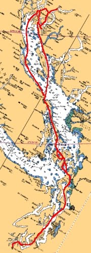
Click to view full image.
Johnstone Strait is a major marine highway to and from Salish Sea and places farther north.  Other than going "outside" you will have to navigate this Strait, and it is a busy route.  When traveling Johnstone Strait you will encounter all sorts of marine traffic - cruise ships, freighters, tugs & tows, log barges, fishing boats, and other pleasure boats.  If that's not enough, Johnstone Strait is also a natural weather and water "funnel."   Johnstone Strait goes pretty much east - west.  To the south you have the Vancouver Island mountains and to the north you have the Coast Range.  All the water in Johnstone Strait and the numerous connecting fjords and inlets all ebb west out of Johnstone Strait - this is important to note.  Weather wise, any bad weather out of the SE is comes up from the Strait of Georgia and gets funneled west into Johnstone Strait, and the summer high pressure that brings the good weather is funneled east down Johnstone Strait.  Depending on your route, at a minimum you will have to deal with about 13 miles of Johnstone Strait.  I have been traveling up and down Johnstone Strait for over 20 years and I have come up with five areas of caution.
  1. Chatham Point.  At this point Johnstone Strait starts from Discovery Passage.  The prevailing westerly winds coming down Johnstone Strait will meet a strong ebb current coming out of Discovery Passage possibly creating very rough sea conditions.  You can listen to the VHF weather radio to get wind speeds from the Chatham Point Light House.  It is not uncommon to hear of gale force winds and four or five foot moderate seas here.  You will also have to contend with marine traffic going north and south.  As a result I tend to avoid cruising this route.
  2. Helmcken Island.  Again, westerly winds and strong ebbing currents can create rough sea conditions here.  Note that north of Helmcken Island is called 'Current Passage' and westbound ship traffic uses this route.  South of Helmcken Island is called 'Race Passage' and eastbound ship traffic uses this route.  To avoid problems you'll probably want to travel the same direction as the marine traffic.You can listen to the continuous VHF weather radio (WX1 Comox Coast Guard Radio) for "Fanny Island" to get reports of wind speeds.  Fanny Island is about five nautical miles west of Helmcken Island.  Again, because of weather and marine traffic I generally avoid cruising this route.
  3. Port Neville.  I generally stay on the far northern side of Johnstone Strait which keeps me out of most of the marine traffic.  However, the seas can get quite rough and confused here from currents that drain out Port Neville as they hit Johnstone Strait.  Also, it seems that there is commonly a lot of debris in the water in this area.  I have seen logs, kelp knots, lines, plastic bags, and other things can can ruin your day.  So keep a sharp lookout and avoid going through any kelp knots where plastic bags and lines can commonly be.  You can find some refuge from strong westerly winds in Port Neville and I've anchored here before, but the current really moves through the channel.  I've only used it in an emergency.
  4. Central Johnstone Strait.  You will find no refuge from the frequent strong westerly winds that blow down Johnstone Strait here.  When looking at Johnstone Strait currents, you will notice that many times there is little or no flood current in Johnstone Strait because of all the rivers that drain into the surrounding inlets and fjords which drain into Johnstone Strait.  My experience is that you want to avoid traveling this stretch of Johnstone Strait during a strong ebb current.  When the westerly winds meet a strong ebb current moving west it will cause big waves to form providing you a rough and uncomfortable cruise.
  5. Western Johnstone Strait - Blackney & Weynton Passages.  Again, the problem here is the mix of westerly winds, strong ebb currents, and marine traffic.  I have been caught in this terrible and dangerous mix and it was not too fun.  One summer the westerly winds were 35 knots or more, the current was ebbing at 5+ knots creating seas of five to six feet with cresting waves.  I had to dodge several ships in the area - meaning I had to temporarily turn broadside to the seas.  When we reached Port McNeill the crew wanted off the boat just to stand on solid ground.
Sunderland Channel looking WSW into Johnstone Strait
The route I suggest (see above route is marked in red) is to travel down Chancellor Channel, Wellbore Channel, Sunderland Channel and turn to starboard just passing the Broken Islands and into Havannah Channel.  If you choose to go this route you will only have to travel about 13 nautical miles of Johnstone Strait. It is a bit longer route, but it makes up for the distance in comfort and scenery.  There are also several good anchorages to wait out any strong westerly blows - Greene Point Cove, Blind Channel Marina, Forward Harbor, and Port Harvey.  You'll get a good idea of what the sea conditions are in Johnstone Strait as soon as you exit Wellbore Channel and go into Sunderland Channel.  If they're too rough, you can choose to return to anchor in Forward Harbor. 

Currents for Central Johnstone Strait for July 25, 2011
In the summer the best plan is to often travel very early in the morning to avoid the stronger afternoon westerly winds.  Check WX 1 Comox Weather Radio and listen for the wind speeds at Fanny Island, along with light house reports from Chatham Point and Pulteney Point (Malcolm Island and by Port McNeill).  Pick your time to avoid traveling during any strong ebbs when there are strong westerly winds.  The currents for July 25 are good because you will be at the 'tail end' of the ebb in the morning.  If you combine this with the previous post of "Summer Trip Planning - Canadian Rapids" you will notice that they go together well.  Now I just hope the wind isn't blowing hard on that day.

Finally, when you get past Johnstone Strait you are in some of the best cruising grounds in the world.  So don't let the challenge of Johnstone Strait stop you.  And, when cruising Johnstone Strait keep a lookout for orcas (Killer Whales).  Near the far western end of Johnstone Strait on the Vancouver Island side is the famed "Robson Bight" where orcas can commonly be seen.